Originally Posted by TOP
Police station or NPP?
Where is the Katong Police Station?


 Newbie
Police station or NPP?
Where is the Katong Police Station?
Junior
Think its referring to the old Joo Chiat Police Station, now known as Katong Village.
BE CENTRED BY ALL AT THE FRINGE OF THE CITY @
Newbie
Yes, I mean the old Joo Chiat Police Station, which is now Katong Village, where Waraku is. They may capitalise on that piece of land by building a taller building there with MRT station underground....exit will be there as it serves the Katong Joo Chiat residents and the other exit is cut across to Marine Parade side.
Newbie
Thanks to all for the info...this speculation of mrt sites is really interesting...I wonder when will LTA announce it...we are only 10 years from 2020 and once constrcution begins...we will have more concrete data of the mrt stations...
even if we travel by car...mrt alway add value to property in the vicinity
Global recession is coming....
Even if we drive, our younger children also cannot drive, hence I always make sure my house is walking distance to MRT station to make it more convenient for them to take public transport to go to school and back etc. (Sometimes I also don't drive if I am going to city to avoid being caught in the bloody traffic jam over there).
Junior
come to think of it, what will happen to property prices once the entire island is wired by mrt, lrts? will the premium for properties located near mrt drop?
Newbie
Why we own car right now? Because current mrt does not take you to every part of the island. When the networks is fully built like Tokyo, London and New York, most of us will do away with the car and properties near mrts will become indispensable. Condo carpark to unit ratio can also be drastically reduced, may be less than 50% or nothing.
BTW, noted soil tests along the marine parade has moved further up to front of Church of Spore. The test line does not support CK's wild guess at Old Police Station.
Senior
As I said earlier, the mrt tunnel will be running along original part of katong. They are worried about another nicoll highway incident. Too much risk at this area.
Newbie
any telltale signs to support yr claim?
Senior
There is marine clay in most part of singapore. It is a weak soil which will expand when comes into contact with water and shrink when dry. Hence, this will lead to quite a lot of soil movement. With the changes in the tide and ground water, it will create dynamic stress on the foundation of buildings.
That is why boreholes is necessary to investigate the soil condition in any deep excavation and basement construction. Piles driven into the ground can sometime go missing overnight given dynamic coastal waves forces for coastal construction. Fortunately, it will not be an issue here.
Junior
was thinking about london and tokyo subways. currently, potential buyers are willing to pay a steep premium for properties located near mrts/lrts. with the network becoming more developed, it means that there would be more supply of such properties.
supply up, price down or normalize? the nature of such a discussion is purely theoretical. anyone else care to add in?
Junior
why won't it be an issue here? care to enlighten the rest of us who ain't civil engineers?
Senior
I meant there is no dynamic coastal forces. It is still marine clay below as it was a sea before. Hope the reclaimed land has consolidated over the years and stronger now.
Newbie
I disagree with DC33, it is no more a technical difficulty from our construction industries after more than 20 yrs of experience in construction of mrts and buildings on reclaimed lands. I have involved in some of these development. In fact, I will be more concern if tunnel has to run below Kotong road where most prewar houses there are supported by weak and aged footings.
The Nicoll highway collapse is compilation of many factors including human errors which can happen everywhere.
Senior
Not sure where the tunnel will be running but if the NE line has run through Chinatown, I do not see any problem running through "Kotong" Road. I believe below Marine Parade road will be a better choice than "Kotong" road. The risk will be lower after what had happened at Nicoll Highway.
Newbie
There is plenty of signs along Marine Parade road that indicate the undergound MRT tunnel will be located.
If your have time to spend, try walking down Marine parade road and look for LTA symbols along the road that indicate soil test done previously. You could see such LTA objects every 50 meters. These OBJECTS with LTA serial numbers are left after months of soil test conducted about six months ago.
There are no such symbols along East Coast road or ECP.
Junior
Believe along Marine Parade is more likely too, and since the whole stretch is reclaimed land, don't think the soil would be an issue.
BE CENTRED BY ALL AT THE FRINGE OF THE CITY @
Junior
As one of the other forumers pointed out, so far, all the soil tests seem to point to the line being sited along amber and marine parade road.
Some have even seen soil test all the way down to Mandarin Gardens although I have not personally gone to look there. The line is supposed to swing into Siglap so it will be interesting to see how it is going to move from Marine Parade inwards.
Newbie
Noticed that along ECP somewhere near ford road where katong park's located there r some LTA works around there as well.
It's very near to the underpass just behind the new Seafront on Meyer's back gate.......
Could it be a soil test as well??

Newbie
I think the work there is not related to MRT. They are building a ramp for the existing underpass.
The soil test at katong park already done sometime back. 2 holes outside Pat school house. 1 hole next to view @ meyer. 1 hole next to equatorial. Couple other test hole all over katong park. You can still see the blue cover of the bore hole if you walk around.
Junior
What about some work, soil-test at Bayshore Road behind the columbus childcare place? any clue?
Newbie
Ya, I was wondering what work is ongoing there as well.. anyone?
 Newbie
Most likely the MRT stations in Marine Parade estate will be located in Marine Parade Centre, and Marine Terrace, around the NPP or the HDB branch office in Marine Terrace. As pointed out by one of the brothers in his earlier posting, the stations need to be situated in areas where there are commercial activities, schools and heavy concentration of public as well as private housing to optimize the ridership. Stations situated in both the above mentioned locations would ideally fit the requirements of LTA.
Just my thoughts.
New Launch Project Specialist
In that case another plus point for Telok Kurau especially those in Lor N.
Newbie
As per LTA blueprint, they have planned two stations in the Marine Parade estate itself; Marine Parade Station, and Telok Kurau Station (this station name could be a provisional name which may be changed once the exact location is announced).
The Telok Kurau Station most probably will be located in the Marine Terrace vicinity where there are heavy concentration of HDB flats, schools, and private housing estate in St Patrick, East Coast Road and part of Telok Kurau next to East Coast Road. Owners of Grand Duchess, Tierra Vue and St Pat Residences which is a stone's throw away from the Telok Kurau Station (if it is really situated in Marine Terrace) will definitely see enhanced value in their properties. Let's see whether their prayers will be answered when LTA announces the exact location of the station after the soil test has been finalised
Newbie
wow LTA blueprint, where can I find it?
Junior
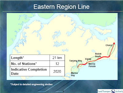
The official version from the Prime Minister's Office, prepared by LTA Rail Network. Graphic by Land Transport Authority and Urban Redevelopment Authority.
http://www.pmo.gov.sg/News/Messages/...e+Together.htm
LTA Rail Network. Graphic by Land Transport Authority and Urban Redevelopment Authority

Junior
Superimposing the govt's presentation , the line seems to follow the ECP quite closely. If the representation is correct/accurate, the stations may be closer to the ECP than further inland.

Newbie
You r using Google Satellite picture. If you map the line properly on google MAP you will find the line pattern matches exactly the contour of Tanjong Rhu,Meyer,Amber,Marine Parade rather than ECP.
Junior
I use the official map from onemap.sg which is more accurate than Google Maps.

 Posting Permissions

 Reply With Quote