Nice job jlix! Yr way of drawing the route with RED arrow looks like RED Enemy Army is charging from Marina Bay towards Changi Airport. Haha.


 Newbie
Nice job jlix! Yr way of drawing the route with RED arrow looks like RED Enemy Army is charging from Marina Bay towards Changi Airport. Haha.
Senior
Originally Posted by sealover
does every GREEN dot represent One station ? thats alot of stations
can do without cars
Senior
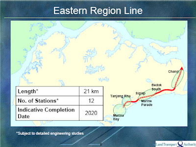
guys, the map above ..Blue line = existing ..
the blue line from marina towards west coast ..has the mrt service started ? can one take a train to Haw Par villa now ?
Junior
The red arrow is from the original LTA drawing.
It foretells China's Red Property Liberation Army (PLA), after buying up Marina Bay, will move East into Tanjong Rhu, Marine Parade ... all the way to Changi.
However, they are intecepted by Singapore's own Blue Rescue Singapore Asset Force (RSAF) at Changi Airport.
There are only 12 stations.
Senior
the west line .. is HarborFront still the last station ??
or has serviced now extended to further west station ?
if not any idea when service will start , after harborfront towards Kent ridge ? or is it One north ?
Junior
Well done on the pics & lines...
I just play play and with rudimentary Paint in my office computer. What I meant to show is that the line will be closer to the ECP than further inland like Mountbatten or Katong. Sealover is right that it tracks tanjong Rhu, Meyer, Amber and Marine Parade very closely. There are 12 stations along this 21 km line so average inter-station spacing would be slightly less than 2km apart.
Junior
well done man!
sorry for the OT, but can help to do the same for the Thomson Line also ? I see very little discussion of this line here. And Thomson Line is supposedly to be "completed by 2018", earlier than Eastern Region Line.
Thanks.
Exalted
next cycle can look out for potential condos near to future mrt lines.
Junior
According to wikipedia, stations may be known as early as 2012. So if you want to take a gamble and pre-empt, better buy before then. Once announced, owners may not want to sell or will ask sky-high prices.
From Wikipedia, the free encyclopedia
Jump to:navigation, search
Eastern Region LineOverviewTypeRapid transitSystemMass Rapid Transit (Singapore)StatusPlanningStations12Services1OperationOwnerLand Transport AuthorityOperator(s)To be announcedTechnicalLine length21 km (13 mi)Track gauge1,435 mm (4 ft 8+1⁄2 in) Standard gauge
The Eastern Region Line (ERL) is an upcoming Mass Rapid Transit line in Singapore and is currently under planning and evaluation. The construction schedule was announced in 2008 with completion set for 2020.[1] Station locations are expected to be announced in 2012 or 2013.[citation needed]
The Eastern Region Line will, from Marina Bay, serve the residential estates of Tanjong Rhu, Marine Parade, Siglap, Bedok South and Upper East Coast, and link them to Changi in the east and interchange with the future Thomson Line.[2] The line will be 21-km long and have 12 stations.[1] This line follows closely to the southern stretch of the previously planned Eastern Region Line; instead of turning towards Expo, it goes eastwards and ends near Changi Ferry Terminal
Newbie
My "guess" of the 12 stations are:
1. Garden by the Bay
2. Tanjong Rhu
3. Meyer
4. Tanjong Katong
5. Marine Parade
6. Teluk Kurau
7. Siglap
8. Bayshore
9. Bedok South
10. Changi South
11. Airport T4
12. Changi Village
The locations of some are quite obvious from forummers' feedback. So keep on feedback...
Deepsea
jlrx u the man!
Newbie
any more analysis???? D15 is
Junior
This one is for Thomson Line. Only part of the Thomson Line because it is longer (27 km vs 21 km) and straighter so the graphic is either too big or the words will be too small.

Junior
Great job! With the existing lines as reference, the prediction of the future lines has high degree of accuracy!
Wondering how the train is going to go through the 90 degree bend of the DTL3 near bedok reservoir?!
Junior
gradual curve, not a sharp bend
Junior
Similar bend for circle line, so should be ok. haha. the tunnel engineers should know better me.
Newbie
maybe NAFA kindergarten will be one station???
Newbie
cool...using official data from PMO and superimposed on the map...that settled the mrt track...as well as provide clues on the stations...thumb up jlrx ..!!
Junior
Well done!!! I like it... nice...
Newbie
so where will tanjong katong, marine parade and telok kurau station be at?????? any one can "map" it? :0
Newbie
wow...this thread is really gettng exciting with the breakthro in map superimposition and all the possible 12 stations for the 21km ERL...
now is 2010...i think new will be out by 2012-2013...
Newbie
Do you all know what is the premium on Condos near a MRT station? How much will the view @ meyer or belvedere cost if a MRT station is announced at Katong park?
 Newbie
10 to 20% higher based on reports in the press. Properties closest to the Circle Line MRT stations are reported to enjoy enhanced value of 10 to 20%.
Newbie
hope to see D15 at 1500psf soon!
Newbie
The Sound is already selling for close to $1500psf. Isnt that a reality? Better located developments at St Patrick Road, like Tierra Vue, Grand Duchess and St Pat Residences directly opposite the Sound are only transacted close to $1200psf, which is still $300 psf short of your wish.
Developers in St Patrick Road are confident that the Telok Kurau MRT station is likely to be located in Marine Terrrace. Shouldnt the value of these 3 condos be worth $1500 psf once the MRT stationed is confirmed to be at Marine Terrace.
Newbie
Newbie
Wow...if MRT station is really gonna be located at Katong Park guess those projects nearby will sell as high as $1800psf in future???
Just my 2 cents
Newbie
$1800 sounds good. So it is a bargain now. If Disneyland or a 3rd IR is announced at Marina East.. the seafront will become like the sail... at least $2000+
Newbie
alamak, no station at katong/joo chiat... what a miss ...
Junior
Don't worry too much about it. Even though the actual station might be situated elsewhere due to infrastructural restriction, the beauty of an underground station is that access points/tunnels can be burrowed underground to link to heavy traffic locales or across roads. So access points into the MRT station could be sited close to some of the more popular locations. Of course, there is a limitation to how long the tunnel can be. Where these access points are going to be depends on economic, demographic and social considerations.
 Posting Permissions

 Reply With Quote
